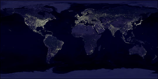
This fascinating image was assembled using data from a number of satelittes orbiting the Earth.
It really highlights where the main centres of population can be found; the eastern half of North America, Europe, India, Japan, eastern China.
On the high-resolution image found at the Visible Earth website you can see individual countries in greater detail.

3 comments:
Whow! Fantastic!
it's interesting how even in satelite pictures we continue the convention of showing the world mapwise this way up - i recently was shown a map of the world the other way up with labels the right way up and i hadn't realised until then that the position of things top/bottom etc did have a profound effect on my conceptualisation of place - and then there's the flattening of the world to make our map - it was years before i realised that the quickest way to north america from the uk was actually to go over scotland rather than just go left as it looked on the map...
maps what we put on them choose to label and not etc are fascinating and i like to feel that our poetry too might in some way act as a mapping process of yes the physical but also the internal world...
i know that going out into the environment and using words using poetry as a way to seeing rather than just looking gives another perspaective on even the most familiar...
it puts a whole new perspective on things doesn't it?
much as little onion says about poetry but also art and music too.
ii really like your site. different to so many others.
Post a Comment